|
Marion County
|
Marion County GAGenWeb a proud part of
Trish Elliott-Kashima, County Coordinator |
|
Marion County
|
Marion County GAGenWeb a proud part of
Trish Elliott-Kashima, County Coordinator |
If you would like to add information, please contact me.
County Creation
Marion County was created on December 14, 1827 from Muscogee and Lee Counties, which had been formed in December 1826. Its boundaries were as follows: Beginning in the center of lot No. 120 in the 10th District of Muscogee extending to the southeast corner of lot No. 130 in the 32nd District in Lee, then due east to the upper corner of lot No. 145 in the 28th District of Lee on the Flint River, then up the river to the southeast corner of lot No. 280 in the 1st District of Muscogee, then to the Talbot County line.
Marion County originally included a lot of what are now Schley, Chattahoochee, Macon, and Taylor Counties.
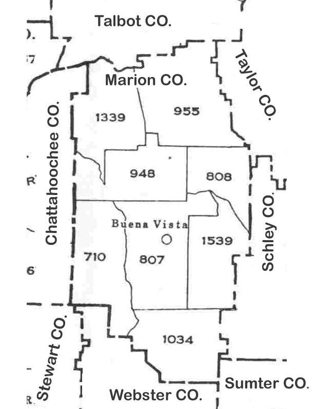
The map to the right shows the approximate locations of Marion County's Districts. It is a freehand work, and definitely not drawn to scale!
Militia Districts
Marion County was first divided into four militia districts:
Captain Walker Captain Blocker Captain Underwood Captain (?) In 1832 this was increased to five numbered militia districts, and in 1836 it was increased to six districts.
In 1838 Marion County was divided into eight militia districts as follows:
Trickam (807th) later called Buena Vista Kinchafoonee (710th) Pan Handle (961st) later became part of Schley County Red Bone (948th) Tazewell (808th) Nubbin Hill (946th) possibly ceded to Schley County(?) Fort Perry (955th) White Water (809th) partly ceded to Talbot and Taylor Counties, remainder later absorbed into 808th, 961st, and 946th Districts Later District additions:
In 1847 the Cut Off (1034th) District was added, created from lands Marion County gained from Stewart County. It was later known as Jacksonville, then Draneville. In 1879 the Brantley (1339th) District was (apparently) cut off from the Red Bone (948th) District. About 1889 the Doyle (1539th) District was added. The town there had previously been called Wigginsville. County Boundaries
In 1829 Marion County lost some land west of Upatoi Creek to Muscogee County.
In 1830 a boundary was established between Marion County and Sumter Counties.
In 1832 Marion County lost land north and west of Upatoi Creek to Talbot County.
In 1847 land was added to Marion County from Stewart County.
In 1849 a portion of Muscogee was added to Marion County.
In 1850 part of Marion County was transferred to Talbot County.
In 1851 a small part of Marion County was given to Macon County.
In 1852 part of northeastern Marion County along White Water Creek ceded to Taylor County.
In 1854 Marion County gave up land to newly created Chattahoochee County.
In 1856 a small portion of Marion County was transferred to Taylor County.
In 1857 the eastern part of Marion County became part of Schley County.
County boundaries have changed over time. Be sure and check neighboring counties for missing relatives and records. Marriage licenses were usually issued in the bride's county of residence. Counties which bordered Marion County in 1830:

- Crawford Northeast, created 1822
- Dooly Southeast, created 1821
- Houston East, created 1821
- Lee South, created 1826
- Muscogee West, created 1826
- Randolph Southwest, created 1828
- Talbot North, created 1827
Counties which bordered Marion County in 1850:
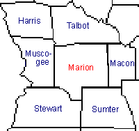
- Macon East, created 1837
- Muscogee West, created 1826
- Stewart Southwest, created 1830
- Sumter Southeast, created 1831
- Talbot North, created 1827
Counties which bordered Marion County in 1853:
- Kinchafoonee South, became Webster
- Macon East, created 1837
- Muscogee West, created 1826
- Stewart Southwest, created 1830
- Sumter Southeast, created 1831
- Talbot North, created 1827
- Taylor Northeast, created 1852
Counties which have bordered Marion County 1860 to present:

~~~~~~~~~~~~~
This page was last updated on -09/01/2016
Compilation Copyright 1999-Present by The GAGenWeb
Many thanks go to Mary Kathryn Kozy, Virginia Crilley, Harris Hill, Carla Miles & Angela Covington
for their work on the site over the years.